Wednesday, June 22, 2022

Zermatt, Switzerland (ski resort)


Zermatt, population 5,800, is car-free. Residents can obtain a permit to park in one of the multi-level parking structures at the edge of town. For all others, it means coming up the mountain on the train or parking your car three miles down the mountain in the village of Taesch and hopping on the train. 

Tucked away behind the horse carriages and the battery powered taxi in this photo is Zermatt's train station--where trains have been whisking people up and down the mountain since 1888.

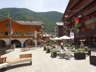
I'm heading up main street. Zermatt receives over two million visitors a year.
This street will lead me to a view of the Matterhorn.
There's the Matterhorn in the distance.
Another view of the Matterhorn. At 14,692 feet, the Matterhorn is one of tallest in Europe. Over 500 have perished trying to reach its summit. 
Looking back toward Zermatt's town center.
View up a hillside.
Tennis complex in center of town.
More of downtown Zermatt.
Filled my water bottle with ice cold water spewing from this water fountain carved out of the wood. Looks like a face with a hat.
Jeez, I snapped this photo to capture the temperature flashing below the Berdoz sign but it didn't come out. It showed 30 degrees celsius (90 degrees Fahrenheit). In the valley floor it was over 100 degrees.
Typical Zermatt taxi.
Parking structures at the edge of town for residents.
Here's the massive block-long parking structure three miles down the mountain from Zermatt.  Behind it is a huge parking lot for tour buses. I count 30 buses. 
It takes several hours to cycle down to the valley floor--passing quite a few waterfalls. 
Lots of little villages along the way. 

Tuesday, June 21, 2022

Saas Fee, Switzerland (ski resort)


Saas-Fee, population 1,500, was way ahead of the environmental pack. It's been car-free since 1951. That means cars are parked in parking structures at the edge of town and you hoof it from there. 

See those wooden huts on stilts (some date back more than 200 years)? Those are raccards. Farmers used them to store grain and/or animal feed. Why are they on stilts? To keep rodents from getting in and eating the food. Right above each stilt you'll see a large round stone--though rodents could climb up the wood--the round stone stops them from going further.


It's pretty quiet on the main street in June. Saas-Fee isn't upscale and doesn't have high-end stores and hordes of tourists like Zermatt, its neighbor on the other side of the mountain but, I think that's why it's a draw for the Swiss. 
Building something new in ski resorts in Switzerland is always a long, very restrictive process. Any new housing has to be 40% wood to keep Saas-Fee's character
Small electric vehicles are allowed. This is a hotel's transport vehicle. 

Jeez, one of Saas-Fee's main streets is being torn up. Not good for business but, guess it's better to do it during the off-season. 
Building on left is school and city hall. 
You can see a ski lift on the left (one of 22 ski lifts). Tennis courts, soccer fields and golf driving range in center. 
Wouldn't mind whacking a few though it's a good thing the netting is up on the left. 
View from below of that bridge I took earlier from above. 
At the edge of town next to car parking structures are several car repair shops. Funny seeing only mini-electric vehicles being serviced. 
One of several multi-story parking structures.
I'm cycling down the mountain. That the village of Saas-Grund below.
Usually in cemeteries you see headstones of all shapes, sizes, colors along with family plots. Here in Saas-Grund one size fits all as there's no deviation. Beautiful chapel. 
Going down I find myself cycling in the middle of the road in some steep parts as the railing doesn't give me peace of mind. 

Thursday, June 16, 2022

Ribeauville, France


I'm still in the Alsace region cycling through vineyards. As mentioned previously the wine growing  encompasses an area roughly 100 miles long and 12 miles wide--mostly lying in the foothills of the Vosges Mountains. My destination is Ribeauville (population 4,500), the last of the "must see" villages according to the tourism guides. I pass this house and the yard is filled with flowers and all kinds of nik-naks.   
After snapping the photo of the yard in the previous photo I spot this woman in the front yard and decide to ask her about the nik-naks. Jeez, what an idiot! Turns out the woman isn't real. Sure fooled me.
This is the main street through Ribeauville. 
Clock tower on main street of Ribeauville. You know I love trivia. Here's a fun fact that'll impress people at a cocktail party: the largest giant Sequoia tree OUTSIDE the USA is here in a nearby forest. 
If you look up on the hill you can see ruins of a castle. Actually there are three separate castle ruins on separate hills and it's popular for tourists hike up the trails and do all three at once. 
In the previous photo you saw the castle ruins of one castle. Here you can see all three.  

However, the most spectacular castle in the region is Haut Koenigsbourg Castle. The medieval castle was rebuilt from 1900-1908 by German Kaiser Wilhelm ll. It's a major tourist attraction and I visited the castle back in 2010. If you scroll through my blog back to 2010 you'll find it.  Also nearby is Fort Mutzig, an underground fortress built in the early 1900's and was used during World War l--it's massive and could house 6,500 soldiers! It is also part of my 2010 blog. You can also type in the addresses below as it won't allow to click on the links.  


https://travelswithpaulwolsfeld.blogspot.com/2010/08/haut-koenigbourg-castle-near.html


https://travelswithpaulwolsfeld.blogspot.com/2010/09/fort-mutzig-france.html

Wednesday, June 15, 2022

Riquewihr, France


I'm still cycling through Alsace's wine country. I pop over a hill and another little medieval village comes into view. 
This village has a French tank from World War ll stationed at its entrance. During the war quite a few of these villages were of strategic importance as many led to roads over the Vosges Mountains. Matter of fact, quite a few were obliterated and were later rebuilt. American soldiers liberated the area and in villages squares I find plaques in French and English detailing the battles.
Main street.
Gated entrance still standing.
Riquewihr (population 1,090) is on the tour bus trail. Most tours use nearby Colmar as their base.
Like in many of the villages, right outside town you'll find local wineries to drop in and have a tasting.
Accessing Riquewihr's main street requires walking right through city hall (Hotel De Ville is French for city hall). 
The drop off spot for tour buses is just around the corner. As tourists make their way up the cobblestone main street.
This really ticks me off. See the sign above the water fountain which reads "Eau non potable"? That means you can't drink the water and I can't fill up my water bottle with cold water. It's a racket! How do I know? Just came through a village several miles away and the water from their fountains were drinkable. They put those signs up to force tourists to buy overpriced water from the trinket shops.
I know these medieval villages are dependent on tourists but, it isn't right. See the sign above this fountain "eau non potable"?
This is Dolder Tower.
Like the color combinations here. 
This is the entrance to Riquewihr from the other end.
Medieval fortifications.
You can see vineyards up on the hill.